
WIA-Loader can assign GPS position data from GPX files to your images and embed it into the EXIF data. To do this, it compares the shooting time of each picture with the GPS position data. If both times are close enough together, the image is 'geocoded', i.e. the GPS position is embedded into the EXIF data.
Geocoding is activated by adding a 'Geocoding' import step to an import profile:
It is important that the camera's clock and the GPS device's clock are (or rather, were, at the time the pictures were taken) as close as possible. If there is a discrepancy anyway, it can be compensated with the 'Shift GPS time (minutes)' setting. The number of minutes set there is added to the GPS timestamps.
Example: The GPS device showed 13:41:22 at the time of the shot, while the camera showed 13:43:55. In this case, you would shift the GPS time forward by 2 minutes to get closer to the camera time.
If you're not sure how big the discrepancy between the camera and the GPS device actually is, choose the option 'Adjust time offset before import'. This opens the map viewer before the import starts, with an embedded time-adjustment panel:
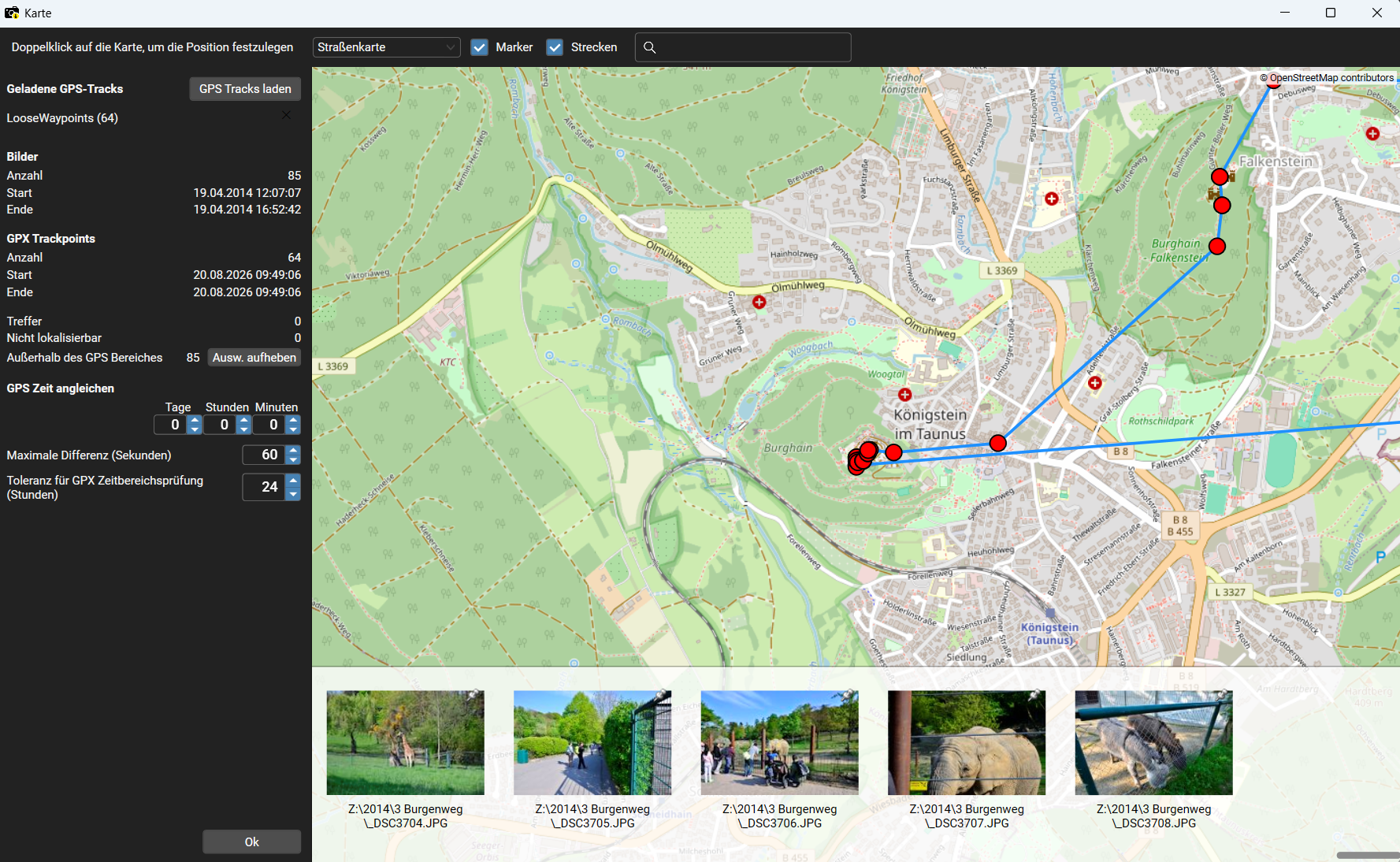
The map viewer shows the GPS track as well as the position of your images on a map (switchable
between street, satellite and topographic view) and additionally lists the images in an image
strip at the bottom of the window. In the time-adjustment panel you can experiment and gradually
dial in the best time offset, while immediately seeing how the assigned position on the map changes.
When geocoding is active, you'll be asked for GPX files at the start of the import. You can select multiple files at once here. WIA-Loader loads all selected GPX files and tries to match them with the imported images. Alternatively, you can specify a central directory in the general settings from which WIA-Loader then automatically loads GPX files.
The data of a matching GPS point is available for further steps in an import profile. WIA-Loader creates various variables for this (see screenshot above). For example, you can include the name of the GPX track in the file or folder name of the saved image.
For images tagged with GPS position data, additional information can be retrieved from the internet at www.geonames.org - for example the country or the nearest city. The results of these queries are stored in variables, which can then be used in other import steps, for example to write the location into the images' EXIF data. If you create a profile with the wizard, these steps can optionally be added automatically.

Here you select what kind of information you want to query. The 'extended place name query' is a special form of the 'place name query' that, among other things, provides results in different languages and also returns the higher-level hierarchy (district -> city -> country -> continent, etc.) for a found location. Address queries are only available for the USA.
To avoid putting too much load on the Geonames.org web service, WIA-Loader caches location queries that have already been made. If an image is located near an image for which a query has already been made, the result of that query is simply reused instead of sending a new query to Geonames.org.

Here the variables for the place name query are defined, as well as various settings for the normal query and the extended query. For the 'normal' place name query, a radius search can be enabled that returns all locations found within a configurable radius.
For the 'extended' place name query you can choose which level to retrieve. The following options are available:

Here the variables for the address query are set.